
Looking Up Iowa Neighbors
A block search in Iowa starts by separating property, tax, election, and community records. The Iowa assessor map and list routes a search to local city or county jurisdictions. Iowa Land Records is the statewide public database for recorded land documents, while maps and neighborhood resources answer different questions. The table marks what each layer can show and where its limits begin.
| Source | What It Shows About a Block | Access |
|---|---|---|
| City or county assessor/GIS | Parcel ID, listed owner, site address, legal description, class, value, and sometimes a map or sketch. | Choose the local jurisdiction through the Iowa assessor map; fields and update schedules vary. |
| Recorder instruments | Recorded deeds and plats that name parties and describe land or lots. | Iowa Land Records has a free statewide index; images and account features have limits. |
| Auditor or GIS map | Parcel, city, county, state, or section layers when the local service publishes them. | Use the local map or the Iowa geodata clearinghouse; check each layer's attributes. |
| County treasurer | Tax account, tax year, amount due, and payment status. | Local account route; payment status does not establish occupancy or title. |
| Des Moines Find Neighborhoods | Approximate neighborhood boundaries, contact and meeting details, downloadable leader lists. | Useful for a Des Moines address; the city warns that data may be incomplete. |
| Iowa voter sources | An individual's registration and polling details, or data in a separately requested voter list. | Self-check online; bulk lists have purpose limits and differ by state or county scope. |
| Directories and Census geography | Past address clues or statistical block and tract measures, each tied to a year. | Library and Census sources; neither is a current parcel ownership map. |
An owner field tells you who the assessor associates with a parcel, not who sleeps there now. A mailing address can point somewhere else, and a parcel can hold more than one dwelling. Renters, relatives, visitors, and other household members may not appear in a property record at all. Read each source for its own purpose: a deed records an instrument, an assessor sets property values and traits, an auditor may publish a map, and a treasurer records tax payment. None is a complete household roll.
Mapping Iowa Neighbors by Parcel
Move from a known address to nearby parcels in small, checkable steps. Iowa's geocoder accepts an address, neighborhood, city, subregion, state, ZIP, postal extension, country, or a single-line query. It returns candidate shapes with status, score, and match-address fields. Those results help normalize a location; they are not an owner search. Its notes also distinguish a postal city from the local city, so confirm which city and county actually govern the parcel.
Before opening a local parcel map, use the Iowa assessor jurisdiction map and directory to route the block question to the city or county office responsible for that address.
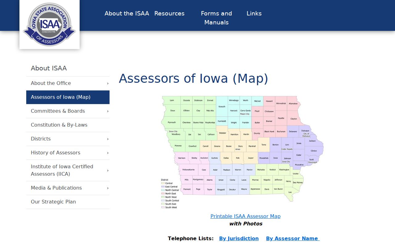
The statewide map identifies the office to contact; use that office's local assessor or GIS map to inspect parcel fields and nearby lots.
- Enter the known address in the Iowa geodata clearinghouse or local map, then note the returned match and any city or ZIP difference.
- Use the Iowa assessor map/list to select the city or county office that covers the address. Do not assume the postal city names the taxing jurisdiction.
- Search that local assessor or GIS site by address, parcel number, owner, or legal description if those fields are offered. Record the parcel ID and map date.
- Inspect the adjacent parcel shapes only as far as the local map allows. A statewide service may include parcel layers, but fields and click behavior need local checking.
- Compare a parcel's legal description with a recorded deed or plat. If the whole street is the question, use the Iowa street directory for the street-level record trail.
This path can produce a list of nearby parcels and their assessed owners, not a verified list of nearby residents. If an official map lacks click-through details, start with its parcel number or legal description and continue at the relevant assessor or recorder. Save the source name and map vintage with each result so that a later map redraw does not silently change the comparison.
Iowa Neighbors and Property Records Around a Block
Iowa property information is split across four custodians. The recorder records instruments such as deeds. The local city or county assessor values property and describes its traits. An auditor may publish an atlas or GIS map. The county treasurer shows tax-payment accounts. A single address can look different across these systems because the records serve different jobs and may update on different schedules.
Local examples show why a statewide promise would mislead. Clark County's assessor displays fields for owner, sales, values, sketches, and photos, and warns that mapped lines are not survey quality. Kossuth County GIS lists roads, property lines, address points, school districts, and section corners; some data requests have a $25 minimum and a $50-per-hour charge. Des Moines County reports weekly GIS updates and daily assessor updates, and has a separate E911 address request route. These are county examples, not rules for every Iowa office.
Iowa Neighbors: Block Lookup Terms
“Block” can refer to several maps that do not line up. Before comparing geographies, write down which one you mean and the date or vintage attached to it.
- Parcel
- A tax and assessment unit tracked by an assessor or GIS, often with a parcel ID, situs address, and legal description. It may cover a lot, several lots, or a larger tract.
- Plat
- A recorded map and related document that lays out lots, blocks, streets, dedications, or easements in a subdivision. A map image alone may not include every legal term.
- City block and lot
- A local subdivision description taken from a plat, recorder document, assessor map, or municipal GIS. Its meaning depends on the named subdivision and recorded description.
- Census block
- A statistical area used for Census counts, not a title map. Block lines and identifiers can change between census vintages.
- ZIP code
- A postal delivery label, not a city block or a parcel boundary. Postal city names may differ from local municipal names.
When a map and deed seem to disagree, capture the parcel ID, subdivision, lot and block, plat book and page, section-township-range, municipal ward or precinct, and map vintage. Compare the legal description to the plotted shape and flag a mismatch instead of forcing the two into one boundary.
Des Moines Neighborhood Contacts
A neighborhood is a social or planning layer, not one statewide legal record. The City of Des Moines' Find Neighborhoods map exposes boundaries, contact details, meeting information, and downloadable Excel or CSV leader lists. It warns that boundaries and data are approximate and may be incomplete. The captured research did not identify individual neighborhood associations by name or record their phone numbers, so the city tool is the contact route to check rather than a claim about a particular group.
| Neighborhood resource | What it exposes | Where it applies |
|---|---|---|
| Des Moines Find Neighborhoods | Map boundaries, neighborhood contact details, meeting information, and downloadable leader lists. | Des Moines; the city labels the map and data approximate and potentially incomplete. |
| Local planning or association source | Use the local office's own boundary, contact, or meeting information if published. | Each other Iowa city or county needs its own official source; no statewide roster was found. |
A boundary can show which group area an address falls inside. It cannot prove that every household belongs to the association or shares a trait. Treat a leader list as a way to contact a group about its public meetings, not as a resident directory.
Iowa Community Map Gaps
The Des Moines map is useful for a Des Moines address only. A person checking a home in another Iowa place must seek that city's planning or neighborhood association information, or choose another geography such as a school area, township, ward, precinct, or Census block. Those boundaries can overlap without sharing the same purpose or update date.
The Iowa geodata clearinghouse offers statewide geographic data, and its boundary service includes parcel, city, county, and state layers. The layer's presence does not guarantee that it carries the fields needed for a neighbor search. Check the description, available attributes, date, and local source before relying on a shape. A municipal boundary may answer which city serves an address; a neighborhood label may instead describe a planning area.
For older block names and community history, Iowa county-record guides cover all 99 counties and point to collections such as directories, plat maps, cemetery surveys, yearbooks, family histories, and organizational newsletters. A collection's county and year range still need to be checked before using it for one address.
Iowa Voter Lookup Limits
The Iowa Secretary of State's voter lookup is built for an individual to check their own registration and polling details. It asks for first and last name, a numeric ZIP code, a numeric house number, and date of birth by month, day, and year. That self-check is not a reverse-address tool or a public list of everyone living on a block.
Bulk voter lists follow a separate request path. The state and county auditor lists have different geographic coverage; a county file is limited to districts in that county, while state products cover statewide or congressional jurisdictions. A requester must state a permitted political, official, or research use, and commercial use is prohibited. The list request information explains the separate process. A voter record reflects election-administration data, not proof of residence or a complete set of current neighbors.
Safe at Home uses a confidential substitute address for enrolled participants under chapter 9E. Never try to infer or publish a protected home address from other records. The regular voter lookup is not a way around that privacy protection.
Iowa Directory Clues for Neighbors
Historical directories can help place a household near a street or civic group in a past year. The Des Moines volumes include street-and-avenue guides and entries for churches, schools, banks, railroads, societies, businesses, and private citizens. A listing may be for a renter, boarder, business, or mailing address, and it does not prove ownership or an uninterrupted stay. The Des Moines Public Library directory page gives the available years and formats; use the Iowa city directory page for the broader collection trail.
Use a directory entry as a historical lead, then compare its printed street guide and year with a plat, deed, census, or another record. Census blocks describe statistical areas that change by vintage, while a parcel plat describes land. The two can help with different questions, but they should not be treated as the same map.
Official Iowa Records and Commercial Tools
Official records are split among local offices and state systems. They identify the kind of record, the office or jurisdiction responsible for it, and often an effective or map date. Commercial neighbor-search tools may package possible address or name associations in one result, but the source, coverage, and freshness of each item can be hard to assess. Use a commercial result as an unconfirmed lead, then look for the matching official record.
| Record category | Official Iowa source can show | Commercial neighbor-search category may offer | Useful check |
|---|---|---|---|
| Parcel and deed | Assessed parcel traits, owner field, legal description, or recorded instrument. | Packaged property or nearby-name associations. | Match the parcel ID and legal description at the local assessor or recorder. |
| Voting | An individual's self-check or data released through a separate permitted list request. | Address associations that may omit the source and date. | Use the Secretary of State's own lookup for its narrow self-check purpose. |
| Business filing | Entity status, filing history, registered agent or officer details, and service addresses where public. | Possible links between names, entities, or addresses. | Search the Iowa business entity record; an agent address is not proof of a person's home. |
For any result, keep the office or tool name, search date, geography, and exact field that matched. Similar names and shared addresses can point to separate people or businesses. A record should lead to a careful check, not a claim about everyone who lives on the block.
Privacy Limits for Iowa Neighbors
Parcel and business records can describe an owner, agent, or service address without establishing where an individual lives. Iowa's business entity search may show registered agents, officers, filing history, and addresses, but the registered agent address is not proof of residence. Some fields are public because of a business filing; they should not be repurposed as a household roster.
Property maps do not list every person in a household. They may omit renters and other occupants, while a neighborhood boundary may include homes that have no association tie. Voter information has its own access rules, and Safe at Home addresses are confidential. A neighbor lookup is strongest when it stays narrow: confirm the record type, use the data for ordinary personal or civic inquiry, and stop if the source does not support a claim about a person.
Privacy and lawful use. Use Iowa public records for a lawful, personal purpose such as learning about local boundaries or contacting a neighborhood group. Do not use an address or record to watch, threaten, harass, or expose another person, and never publish a protected Safe at Home address.